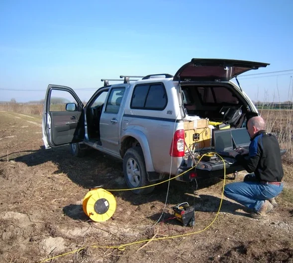
In Mildura, the contrast between the Murray River floodplain and the underlying Blanchetown Clay creates a tricky target for any geophysical survey. We often see projects where standard drilling misses lateral changes—a sand channel that will daylight into an excavation, or a calcrete layer that looks solid on the log but is actually only 300 mm thick. That is exactly where seismic tomography pays off. By shooting a spread of geophones across the site and picking first arrivals from multiple shot points, we build a velocity model that shows you the real geometry: where the clay thickens, where the sand lenses pinch out, and how deep you need to go to find competent material. For deeper targets, seismic reflection gives us a continuous image of stratigraphy well below 30 metres, something that is critical when you are designing deep foundations or assessing basin structure.
A velocity model from seismic tomography gives you a cross-section you can hand directly to the geotechnical engineer—no interpolation guessing between boreholes.
Quick answers
Can seismic tomography replace boreholes on a Mildura site?
No, and we never recommend it. Tomography gives you a continuous velocity cross-section, but you still need at least one borehole to calibrate the velocity-to-material conversion. We use borehole logs to assign lithology to velocity ranges—without ground truth, the model is just velocities. The smart approach is to drill two or three boreholes along the seismic line and use them as control points for the inversion.
What is the typical cost for a seismic refraction survey in Mildura?
How long does a seismic tomography survey take from start to final report?
Field acquisition for one or two spreads is usually completed in a single day. Processing and preliminary interpretation take three to four working days. If you need the velocity cross-section urgently for an excavation decision, we can send a draft section within 24 hours of demobilisation. Final signed reports with all deliverables typically go out within seven working days of the field work.
What depth can seismic reflection reach in the Murray Basin sediments?
With our accelerated weight drop, we typically image reflectors down to 80–120 metres in the Murray Basin, depending on the clay-sand layering. Where the target is deeper—say the top of the Renmark Group—we bring in a larger source and can extend the section to 250 metres. The key limitation is the seismic attenuation in dry, loose near-surface sand; we mitigate that with closely spaced shots and careful static corrections.