Together, we solve the challenges of tomorrow.
LEARN MORE →In the dynamic landscape of Mildura, where the mighty Murray River has carved its path through ancient terrains, the stability of slopes and retaining walls is not merely a construction concern—it is a fundamental geotechnical imperative. This category encompasses the comprehensive assessment, design, and remediation of natural and engineered earth structures, addressing everything from riverbank erosion along the Murray to the deep excavations required for urban development. For property owners, civil contractors, and municipal planners in the Sunraysia region, understanding and managing lateral earth pressures, soil retention, and mass stability is critical to safeguarding infrastructure, protecting property values, and ensuring public safety. The services within this domain, including specialised slope stability analysis and advanced active/passive anchor design, form the backbone of resilient development in a region where soil conditions can vary dramatically across short distances.
Mildura's geological setting presents a unique set of challenges that demand localised geotechnical expertise. The region is underlain by the Murray Basin sediments, a complex sequence of unconsolidated to semi-consolidated sands, silts, and clays deposited over millions of years. Of particular note are the Blanchetown Clay and the overlying Woorinen Formation, which can exhibit dispersive behaviour—a phenomenon where clay particles deflocculate in the presence of water, leading to internal erosion and sudden collapse. This is a well-documented hazard in north-western Victoria, directly influencing slope stability and the long-term performance of retaining structures. Furthermore, the calcareous sands common to the area, often weakly cemented with calcium carbonate, can present a misleadingly competent face that rapidly degrades upon exposure to weathering or changes in moisture content. The semi-arid climate, punctuated by intense rainfall events, creates cycles of desiccation cracking followed by rapid infiltration, a perfect storm for triggering shallow landslides and wall failures.
Navigating the regulatory framework is a non-negotiable aspect of any slope or wall project in Mildura. All geotechnical investigations and designs must comply with the National Construction Code (NCC) of Australia, which in turn references the relevant Australian Standards. The primary standard governing retaining wall design is AS 4678-2002: Earth-retaining structures, which mandates limit state design principles considering both ultimate and serviceability conditions. For slope stability assessments, practitioners rely on guidelines from the Australian Geomechanics Society (AGS), particularly the AGS Landslide Risk Management Guidelines, which provide a systematic framework for assessing risk to property and life. Additionally, local council requirements from the Mildura Rural City Council often stipulate minimum design life expectations, particularly for walls adjoining public land or waterways, and may require peer review of geotechnical reports for significant structures. Compliance with these standards ensures that designs account for the specific failure mechanisms observed in the region, such as piping in dispersive soils.
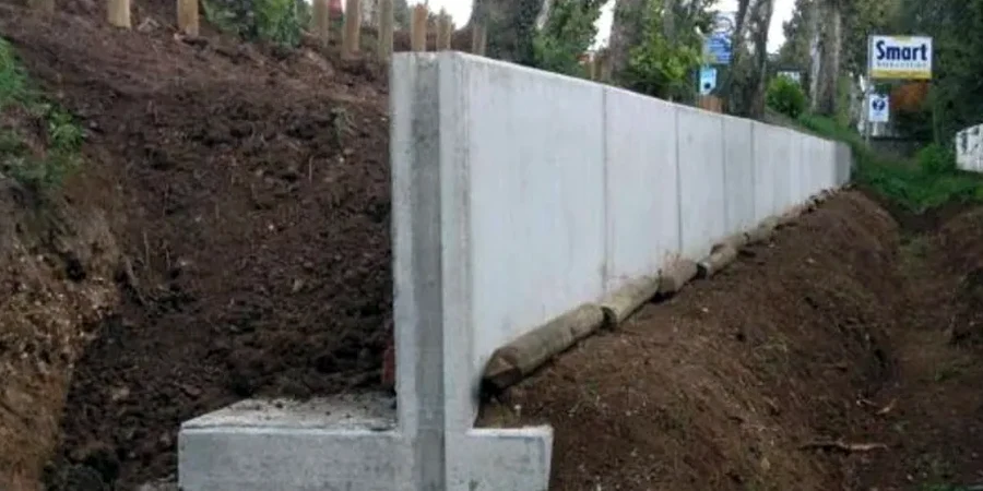
The practical applications of slope and wall engineering in Mildura are extensive and varied. Residential developments on the undulating sand hills overlooking the Murray floodplain frequently require engineered cut-and-fill batters and retaining walls to create level building platforms, making a detailed slope stability analysis essential to prevent future movement. Infrastructure projects, including road widening along the Sturt Highway and the upgrade of irrigation channel networks, demand robust retention solutions where space is constrained. In the agricultural sector, the prevention of bank collapse in irrigation storage dams and the stabilisation of access ramps are critical operational concerns. For deep basements in the Mildura CBD or anchored shoring for bridge abutments, the use of temporary or permanent ground anchors is often the only viable solution, requiring precise active/passive anchor design to transfer tensile loads into competent strata beneath the weathered surface layers. Each project type demands a tailored approach that respects the local soil-structure interaction.
The primary triggers are linked to the local geology and climate. Dispersive clays, such as the Blanchetown Clay, can erode internally when wet, leading to tunnel erosion and sudden collapse. Intense rainfall after dry periods infiltrates desiccation cracks in Woorinen Formation soils, increasing pore water pressure and reducing effective stress. Riverbank erosion by the Murray River also undercuts natural slopes.
Yes, a building permit is generally required for any retaining wall exceeding 1.0 metre in height, or any wall with a surcharge loading from buildings or traffic. The Mildura Rural City Council will require structural drawings and geotechnical documentation that demonstrate compliance with AS 4678-2002. Walls on property boundaries may also require protection works notices under the Building Act.
Dispersive soils can be identified through a combination of field indicators, such as the presence of erosion tunnels or milky-coloured water in puddles, and laboratory tests like the Emerson Crumb Test or Pinhole Test. It matters because dispersive clays can wash out through drainage gravels and joints, creating voids behind a wall and leading to a build-up of hydrostatic pressure and eventual structural failure.
An active anchor is tensioned against the structure during installation, immediately applying a pre-determined load to prevent any movement. A passive anchor is not tensioned; it only develops its resisting force as the ground mass begins to move and deform the steel tendon. Active anchors are used where strict deflection control is required, while passive anchors are common for general slope stabilisation.